New Orleans is Going Dutch

A City Forever Changed

Journalist

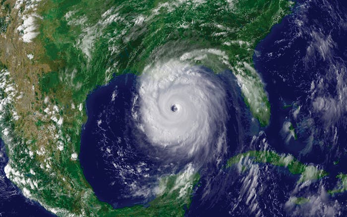
The storm may have hit almost 15 years ago, but the impact of hurricane Katrina can still be felt to this day.

Katrina was a category 3 hurricane that caused over 1500 causalities and more than 100 billion dollars’ worth of damage. This natural disaster changed the lives of many people and the history of New Orleans. On 29 August, 2005 many homes and neighborhoods were destroyed. In the years since, we have seen the resilience of the people in our city, but there is still much to be done. One of the primary things is preventing another disaster like Katrina from happening. Of course, the disastrous flooding in New Orleans was caused by the occurrence of a hurricane, but there are many underlying issues that we can and must solve to reduce the risk of flooding in the future.

Flood Map of New Orleans Indicating the Breach Location
New Orleans After Hurricane Katerina

Feel the Ground Sink Under Your Feet

Journalist

One of the main reasons why New Orleans is susceptible to flooding is due to high rates of land subsidence.

Using satellite images, it was determined that the earth’s surface in New Orleans is sinking around 6.4 mm per year on average with maximum sinking of up to 40 mm per year. A few millimetres do not seem like much, but if you think 10 years ahead this can amount to 40 centimetres. Especially in areas where subsidence rates are high, this can cause problems for residential houses.

If you build your house with the door on ground level, you have to build steps to go into your house after 10 years of subsidence. The subsidence rates in New Orleans are much higher than the sea level rise rate (±2 mm per year), so it is clear that subsidence is a very important process that has to be studied and combatted. Satellites can only give us information on current and past subsidence rates, but we need other methods for future predictions.

Subsidence Foundation Issues

Getting Your Hands Dirty

Journalist

To be able to predict rates of subsidence in the future more data are needed. In this case, we have to get up close and get our hands dirty.

Recently, a team of Dutch researchers from the research institute Deltares visited New Orleans. They came here to collect soil samples that provide information on the composition and permeability of the soil underneath our city. They also dug observation wells to track the movement of groundwater, not only now, but also in the future. The goal of collecting all these data is to know what subsidence will be in 2050 and understand the disaster risk the city faces in the future. This is Priority 1 of the Sendai Framework for Disaster Risk Reduction.

© Deltares | Collecting Soil Samples in New Orleans

Combatting Subsidence

Journalist

We have already started combatting flooding by taking several ‘hard’ measures. However, a more indirect and slow process like subsidence is less easy to solve.

The Lake Borgne surge barrier, the West Bank surge gate and several levees are in place, but now underlying causes like subsidence ban be addressed. Using the data collected by the Dutch researchers, different solutions against subsidence will be evaluated. Reduced drainage, permeable streets, rainproof gardens and many other measures are considered.

The evaluation will give information on how much these measures cost, how much maintenance is needed and how effective they are. This will help city officials and local water experts to get a better idea of where to implement projects that hold more water instead of pumping it away. In this way, we can get a better grip on combatting subsidence and help to prevent future flooding in New Orleans.

© Dan Swenson | 500-Year Storm Flooding