Water as Leverage in Semarang

City Overview: Semarang

Water as Leverage

Semarang is the largest city on Java’s north coast and one of Indonesia's main commercial hubs.

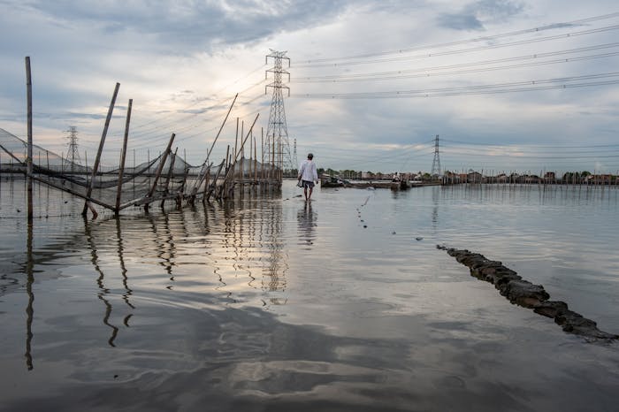
The low-lying land around Semarang consists of alluvial plains formed by hundreds of small rivers. The city has historically faced water challenges such as drought, land subsidence, landslides, water pollution, and floods, all of which are likely to become more severe as a result of climate change. Higher surface temperatures, increased rainfall intensity, rising sea levels, and extreme weather patterns are all projected for the region in the coming century, creating problems like income fragility, food scarcity, and forced migration.

Land subsidence has by far the largest impact on flood risk; some parts of central Semarang sink up to eight centimeters per year. The low-lying areas of Semarang are subject to coastal flooding and pollution, while the mountainous areas suffer from drinking water scarcity, landslides and flash floods.

Semarang has been developing various infrastructural projects for sewage, water distribution and water treatment. The city has also been developing plans for energy provision, residential development and harbor expansion. These efforts must keep pace with large and often unregulated growth, making addressing water challenges more difficult.

© Mott MacDonald | Water as Leverage

A Sinking City

Water as Leverage

Semarang is a sinking city, subsiding 8 centimeters each year in the most severely affected areas.

By comparison, sea level rises approximately 2 millimeters per year due to climate change. The combination of sinking land and rising seas is increasingly exposing the city's 1.5 million inhabitants to serious risks from flooding and causing damage to housing and infrastructure.

Land subsidence is caused by groundwater extraction, natural consolidation of alluvium soil, and pressure from the weight of buildings. In Semarang, the main cause of land subsidence is the extraction of drinking water from the deep aquifers beneath the city. Though it is an urgent problem, it is also a largely invisible one, resulting in a lack of a sense of urgency among inhabitants.

Restoring subsided areas to their previous levels is basically impossible. Nevertheless, attempts to elevate land are common in the harbor areas of Semarang, where there is a clear and direct economic benefit from effective flood mitigation. Also, in neighboring coastal villages, land owners are elevating their properties and public spaces. This results in the phenomenon of ‘sinking houses’, where the ground floor of a building slowly disappears below the surface, forcing people to move to the first floor and, if they can afford it, build another floor on top.

© Cynthia van Elk | Water as Leverage

Siltation of Rivers and Flash Floods

Water as Leverage

The rivers of Semarang play an important role in the drainage of surplus water from the city.

Due to natural sedimentation processes and inadequate maintenance, the rivers are slowly filling with silt. Informal settlements are also erected in these areas, filling and encroaching on the riverbeds even more. Flash floods – sudden floods from high amounts of precipitation upstream – affect Semarang on an incidental basis. Restriction of waterflow in the rivers due to filling impedes Semarang’s drainage system during these intense events.

Semarang’s government recently initiated a program to ‘normalize’ the rivers, which involves canalization in order to increase discharge speed significantly. However, this may impede water recharge for the shallow aquifers which would contribute to further land subsidence. Hardening the river beds also has negative consequences for the flora and fauna nearby. Most main canals have already been normalized, except for the eastern Banjir Kanal Timur canal.

In lower-lying areas, drainage of floodwaters is sometimes impeded by gravity: during high tide, gravitational discharge is insufficient so pumps must be run to rid the city of the surplus water. In order to prevent the old city center from waterlogging, Semarang also installed a large retention pond to store floodwaters and control groundwater levels.

© Cynthia van Elk | Water as Leverage

Loss of Natural Coastal Defenses: Mangroves

Water as Leverage

Semarang’s coastline was once protected from the ocean by long stretches of mangroves.

An intact mangrove forest provides many ecosystem services, including preventing coastal erosion and stimulating sedimentation processes. In addition, mangroves function as natural filters for river water before it is discharged to the sea, are breeding grounds for fish populations, have a cooling effect on air and reduce windspeeds during cyclones. Overall, healthy mangrove forests form a protective buffer between the sea and the land.

Urbanization and aquaculture practices have caused the large-scale destruction of the mangroves in Semarang, resulting in coastal erosion, flooding, and salt-water intrusion. Along with its mangroves, Semarang lost its natural coastal protection. If no measures are taken, the loss of the mangroves, combined with continuing land subsidence, could lead to the complete inundation of the city’s center in the future.

Fortunately, programs are currently operating to restore the mangrove forests, upgrade informal housing in the coastal area, and stimulate ecotourism. Though some attempts are misguided, many initiatives are successful: once sedimentation is stimulated and seeds of mangrove trees are planted, the rest of the process is self-sufficient.

© Cynthia van Elk | Water as Leverage

Water Pollution

Water as Leverage

Pollution in Semarang clogs vital drainage canals, increases the spread of illness, and contributes to issues of water scarcity in the city and its surrounding areas.

Pollution occurs largely as a result of unregulated dumping of industrial and household waste into the waterways. In order to protect the main water supply of Semarang, the Jatibarang reservoir, several pollution abatement projects are underway. Current projects for the Jatibarang reservoir and the upstream area of the Semarang River include the establishment of a conservation zone and construction of a trash rack.

Preservation projects have also been planned near the waterfront, including the development of an eco-district and a program for collective water management of the Kaligarang River. Apart from the creation of an ecological industrial area, there are currently few plans to reduce industrial sources of water pollution, which remains an active area of concern.

© Cynthia van Elk | Water as Leverage

Drought and Drinking Water

Water as Leverage

Water demand in Semarang is expected to increase up to 200% in the next 15 years.

At the same time, droughts are expected to become more frequent due to climate change. Droughts not only create water scarcity, but also heighten the risk for devastating landslides.

Retention ponds for water supplies are set to be built on the Semarang River and along the eastern coastline. The impoverished southern parts of the city, like Candisari, are places where it is more difficult to install resilience measures against drought and landslides. In these cases, revegetation around infrastructure could be an initial opportunity to reduce the incidence of landslides.

Freshwater in Semarang is sourced from groundwater and surface water, including rivers, canals and small water reservoirs. By far the biggest water supply project in the upstream areas is the construction of the Jatibarang dam, which regulates the main tap water supply of Semarang. Catchment tunnels were constructed and the upstream drainage system was separated from the downstream system. This was done in order to increase overall efficiency, since the upstream drainage system only utilizes gravity while the downstream area requires additional pumps.

Image: Cynthia van Elk

Coastal Defense Master Plan

Water as Leverage

Semarang is currently being transformed into a system of dikes and polders as part of the city's Coastal Defense Master Plan.

The cohesive Master Plan is rooted in the construction of a large seawall in the northeastern part of the city. This will be done in conjunction with the installation of a polder system featuring retention ponds and a series of protective dikes along the coastline that create water storage basins for heavy rainfall. This seawall will also serve as a highway to connect Semarang with regional traffic routes between the East and West of Java. A series of pumps and water basins will drain the new system of polders.

In the downstream areas, pumping stations and automatic water gates have been installed throughout the city’s canals and rivers. The city is also undertaking endeavors to normalize the west-canal and the Tengang, Sringin and Semarang Rivers. The polder system is further supported by the Kali Banger, which is being dredged and deepened in anticipation of dam construction and pump installation. Furthermore, mangrove restoration projects are underway to enhance the natural coastal protection systems of the city. Development of coastal defenses coincides with current informal housing upgrading programs in the coastal area of the Tanjungmas district and the creation of opportunities for eco-tourism.

Though the plans have already been discussed at all levels of governance, the "weakest links" of this approach to coastal defense in Semarang still need to be critically examined.

© Cynthia van Elk | Water as Leverage

Created in partnership with: FABRICations, 100 Resilient Cities and Architecture Workroom Brussels